Yn ystod gwyliau’r haf byddai hi’n braf cael mynd â’r mab i sinema i wylio ffilm Gymraeg, hen neu newydd, ond does dim byd o gwbl.
Beth yw’r cam ymarferol nesaf tuag at ddarparu hyn tybed?

Yn ystod gwyliau’r haf byddai hi’n braf cael mynd â’r mab i sinema i wylio ffilm Gymraeg, hen neu newydd, ond does dim byd o gwbl.
Beth yw’r cam ymarferol nesaf tuag at ddarparu hyn tybed?
Mae Blociau Rhif yn raglen deledu animeiddiedig sy’n helpu plant ifanc i ddysgu rhifau.
Mae hi’n wych bod y rhaglen wedi’i chynhyrchu yn Gymraeg, ac yn cael ei gwylio a mwynhau mewn cylchoedd meithrin, ysgolion, cartrefi, ac ati ar draws Cymru a thu hwnt.
Ond mae problemau, a diolch i’r athrawon sydd newydd dynnu fy sylw atyn nhw.
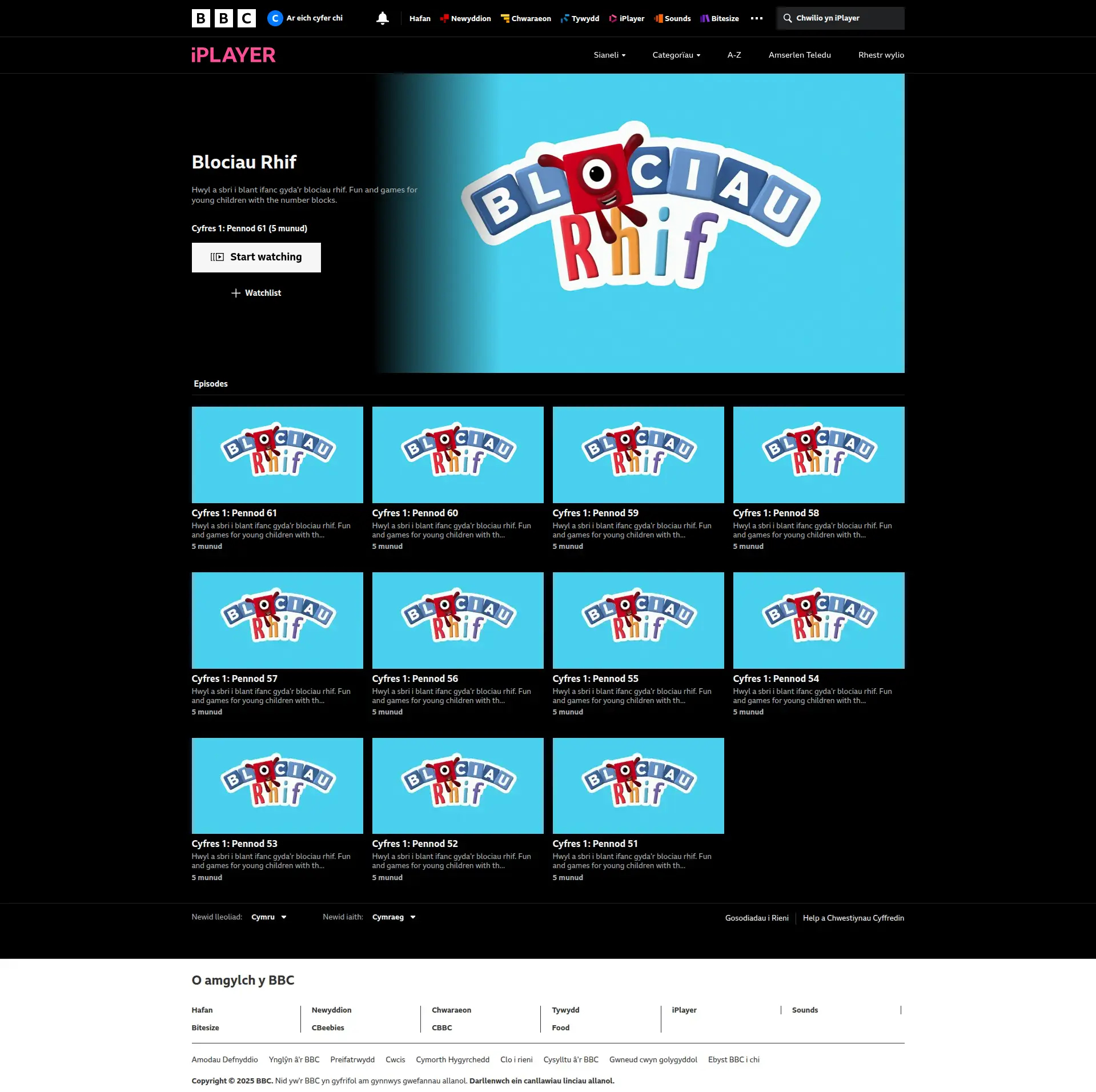
Ar hyn o bryd mae 11 pennod Blociau Rhif sydd ar gael ar Clic ac iPlayer. Mae pob pennod yn cael ei darlledu ac wedyn mae ar gael i’w ffrydio am gyfnod o fis. Wedyn mae hi’n diflannu oddi ar y gwasanaethau ffrydio.
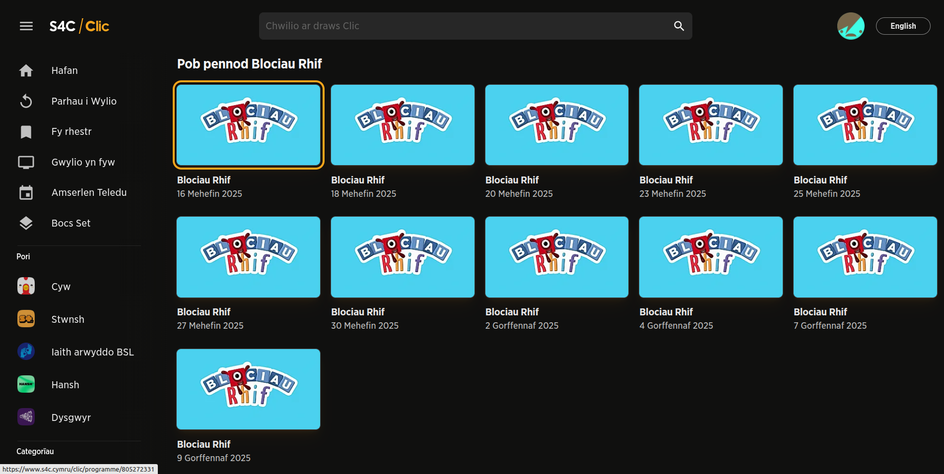
Os ydych chi’n lwcus efallai bod un o’r penodau yn perthnasol i’ch blentyn chi o ran ei thaith/daith ddysgu bersonol ar unrhyw adeg. Efallai ddim. Nodwch nad oes llawer o fetadata unigryw fesul rhaglen megis enw, delwedd, a disgrifiad. Mae hi’n anodd canfod neu gofio pennod penodol.
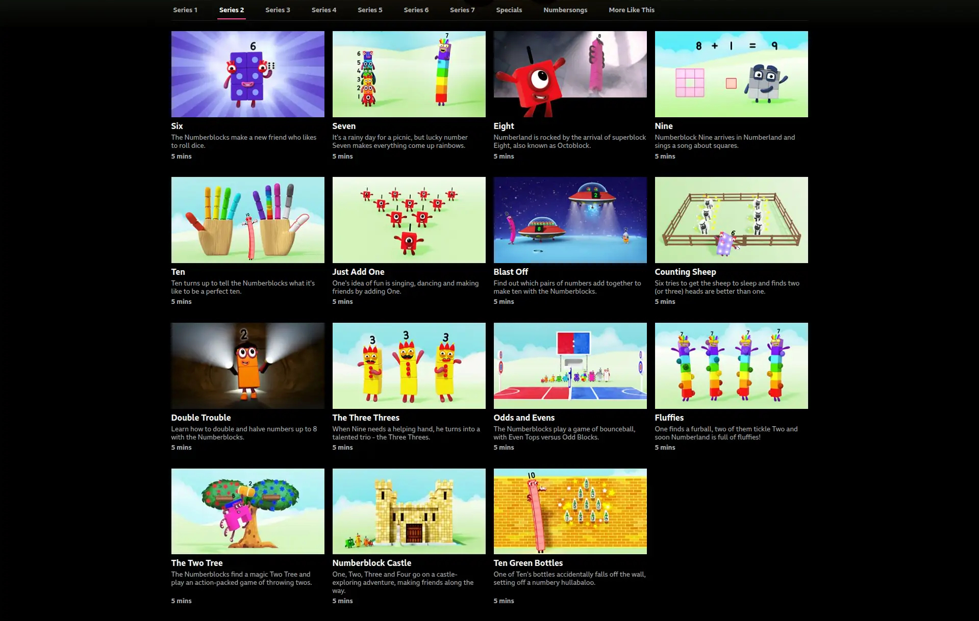
Dyma’r sefyllfa yn Saesneg. Mae modd cymharu’r un rhaglen sef Numberblocks sy’n digon poblogaidd i gael ei ymgorffori mewn crysau-t, teganau, ac adnoddau dysgu.
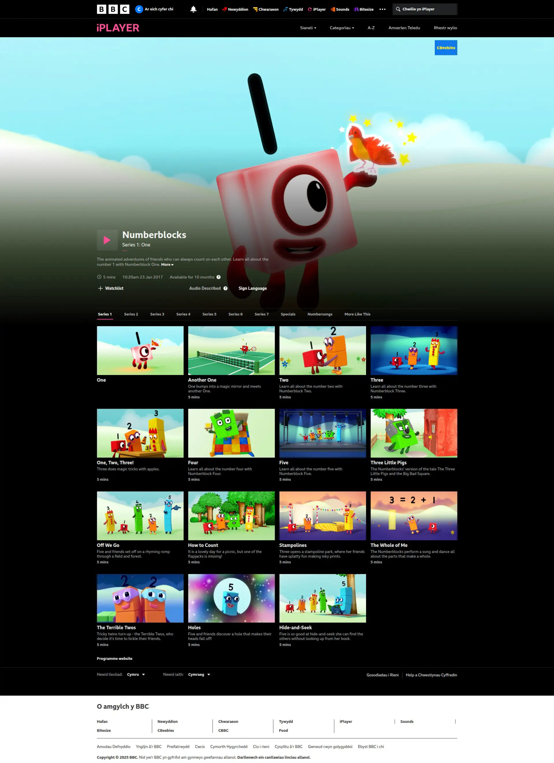
Er ei fod yn dweud bod y rhaglen yn dod i ben mewn 10 mis, credaf fod hyn yn cael ei adnewyddu’n gyson. I bob pwrpas “amhenodol” yw’r cyfnod gwylio. Ta waeth, mae’n lawer mwy na mis fesul rhaglen.
Dyma gyfres gyntaf ac mae modd i blentyn ddechrau ar y dechrau drwy wylio’r rhaglen gyntaf ymlaen drwy’r holl gyfresi.
Dyma gyfres 2.
Dyma gyfres 3.
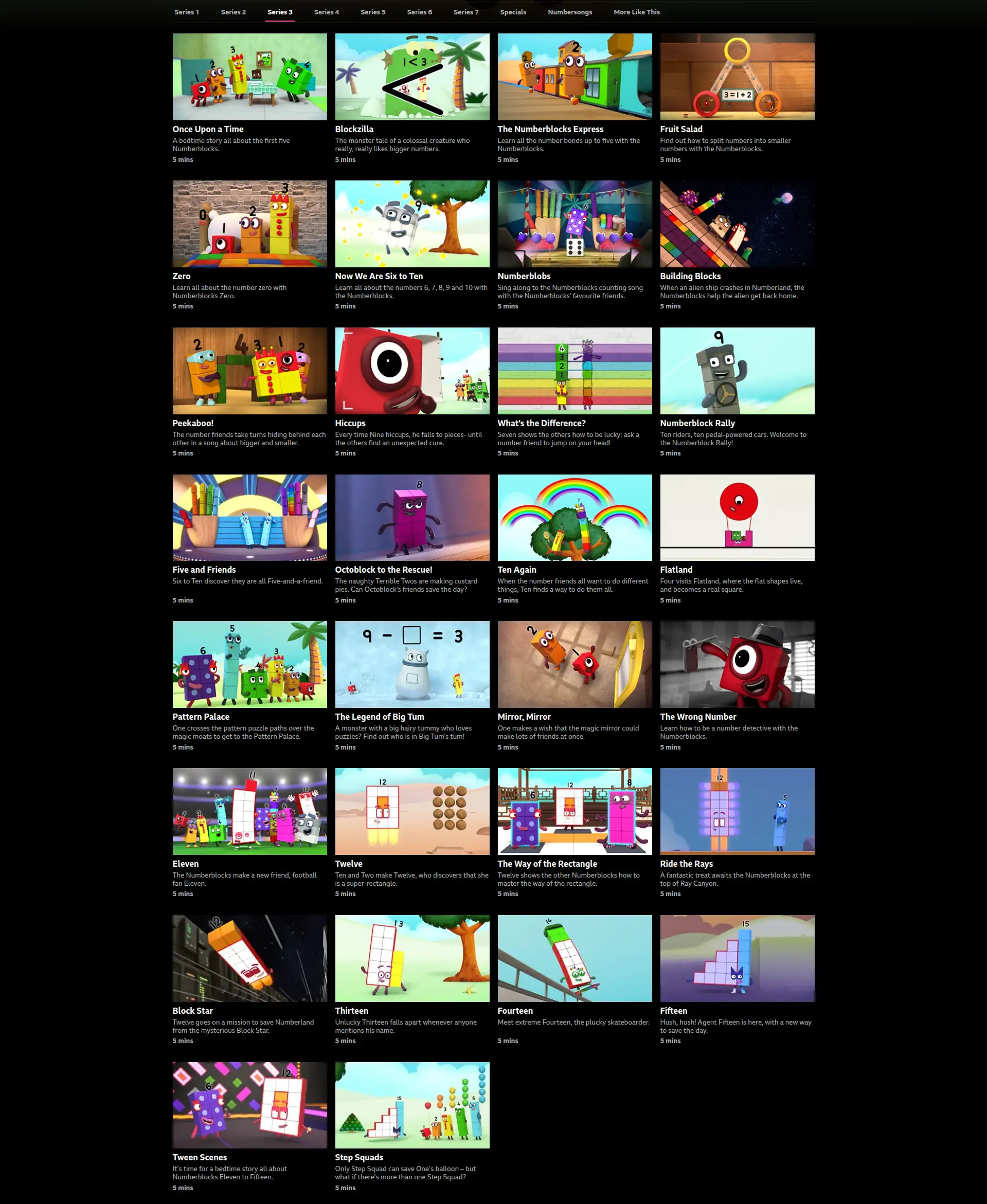
Dyma gyfres 4.
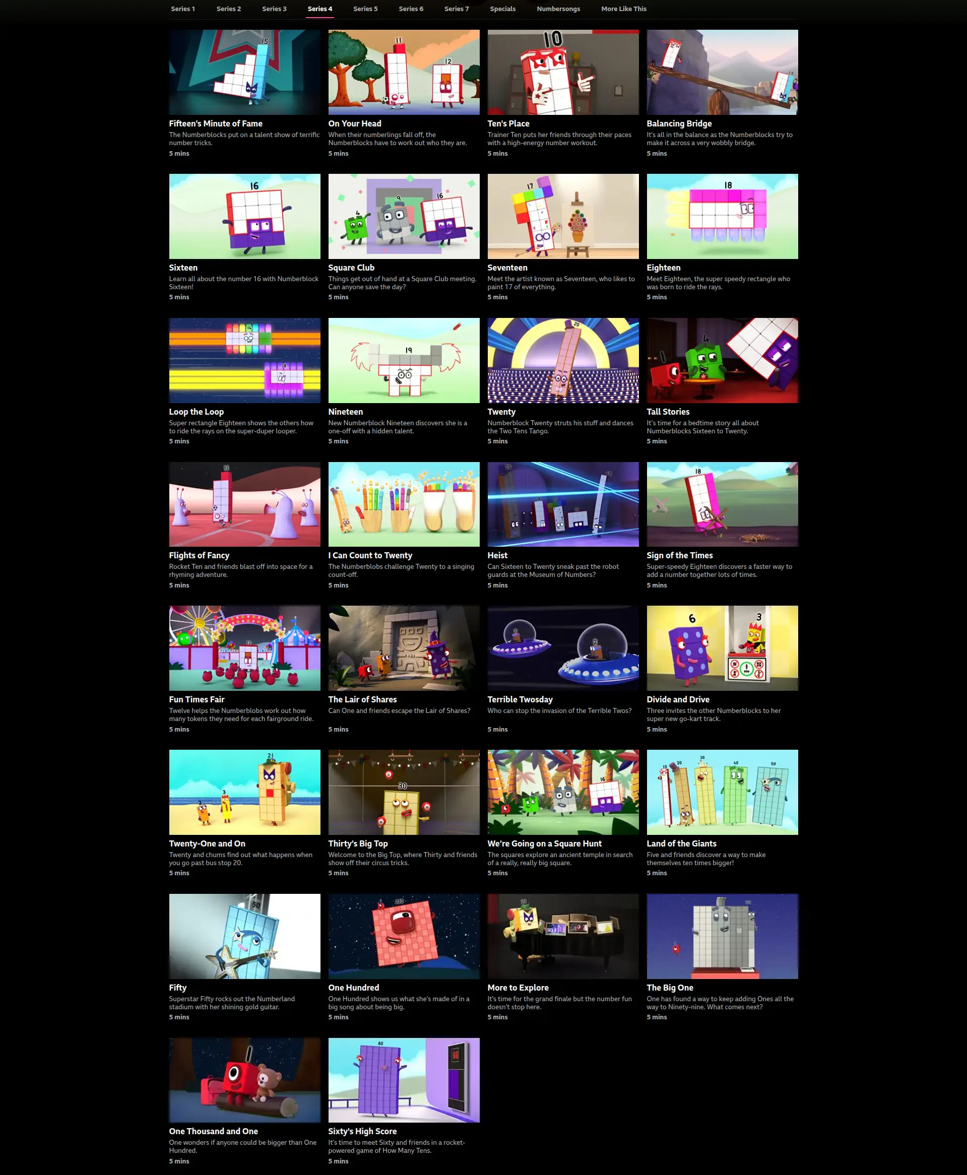
Ac yn y blaen.
Mae cyfresi 5 i 7 yna hefyd, ac mae rhai “specials” a “numbersongs” yn ogystal. Yn wir mae cyfrif yr holl eitemau cynnwys yn her yn ei hun.
Fel arall mae modd pori drwy’r teitlau a delweddau yn hawdd achos mae cyfoeth o fetadata. Byddai rhai plant eisiau gwylio’r un rhaglen tro ar ôl tro, ac yna dysgu pethau hanfodol a phwysig.
Mae rhywun dylanwadol yn rhywle wedi sylweddoli bod argaeledd y rhaglen Saesneg hon yn flaenoriaeth hynod o bwysig. Os felly pam nad yw’r rhaglen Gymraeg yn cael yr un flaenoriaeth? Ar hyn o bryd mae’r Gymraeg yn cael ei gwthio i’r ymylon. Mae hyn yn sefyllfa rhwystredig iawn i lawer o bobl.
Mae datrysiad amherffaith dros dro. Mae dibenion addysg yn eithriad dilys i hawlfraint. Dan y gyfraith mae hynny yn cyfrif fel “delio teg” neu “delio’n deg”. Mae ffyrdd technegol o archifo rhaglenni ar gyfer pwrpas fel hyn. Efallai bod rhai cylchoedd meithrin ac ysgolion mewn lle i ddefnyddio nhw i gopïo rhaglenni.
Ond os ydyn ni o ddifrif am addysg ein plant mae eisiau gwneud hi’n lawer haws i’r holl gartrefi, teuluoedd ac eraill ffrydio rhaglenni yn ôl anghenion penodol pob plentyn, neu ar eu mympwy.
Annwyl S4C, annwyl BBC, annwyl gwmnïau cynhyrchu, a deiliaid hawlfraint… rhowch yr holl raglenni Blociau Rhif ar gael i BAWB drwy’r amser drwy Clic ac iPlayer os gwelwch yn dda! Mae rhaglenni pwysig eraill ond dechreuwch gyda Blociau Rhif. Mae siawns well bod y plant yn dod yn ôl i wylio mwy o raglenni wedyn.
Annwyl lywodraeth, annwyl Gomisiynydd y Gymraeg… defnyddiwch eich llais i sicrhau bod polisïau ac arferion y diwydiant teledu yn sicrhau bod mynediad llawer gwell at raglenni (sydd eisoes yn bodoli!). Dyma gyfleoedd eraill i blant ddefnyddio’r Gymraeg tu fas i’r dosbarth. Mae llawer o sgwrs wedi bod am hyn yn ddiweddar, gan gynnwys ymchwil y Comisiynydd ar ddefnydd y Gymraeg ymysg plant. Mae teledu yn berthnasol i’r sgwrs.
Yn y cyfamser dyma enghraifft amlwg o sut mae’r diwydiant teledu Prydeinig yn rhoi oedolion sydd am roi addysg Gymraeg i’w plant – gan gynnwys y rhai nad sy’n siarad Cymraeg yn rhugl eto – dan anfantais.
Fe ges i ymateb fis diwethaf wrth rywun sy’n gwybod mwy am hyn yn dweud bod modd i rai gael cyfrif Hwb y llywodraeth a gwylio 90 pennod o Blociau Rhif sydd ar gael yn barhaol i “bob ysgol, bob athro, bob disgybl yng Nghymru” ymhlith rhaglenni eraill. Mae cyfrif “ar gael i bawb yn ein system addysg”. Mae hyn yn swnio’n addawol iawn. Ar hyn o bryd dyw hi ddim yn glir i mi sut mae rhiant yn cael cyfrif ar Hwb. Nid yw hi hefyd yn glir i mi pam nad yw’r 90 pennod ar gael yn hawdd trwy iPlayer, Clic ayyb. Mae’r Gymraeg yn parhau i gael ei thrin yn llai ffafriol na’r Saesneg yn yr achos yma (a sawl achos arall o raglenni teledu).
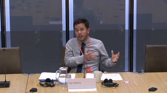
Heddiw ces i gyfle i gyflwyno tystiolaeth i bwyllgor Senedd am tro cyntaf.
Roedd hi’n brofiad gwych mewn sawl ffordd, ac o’n i’n hapus iawn i drafod technoleg a’r Gymraeg.
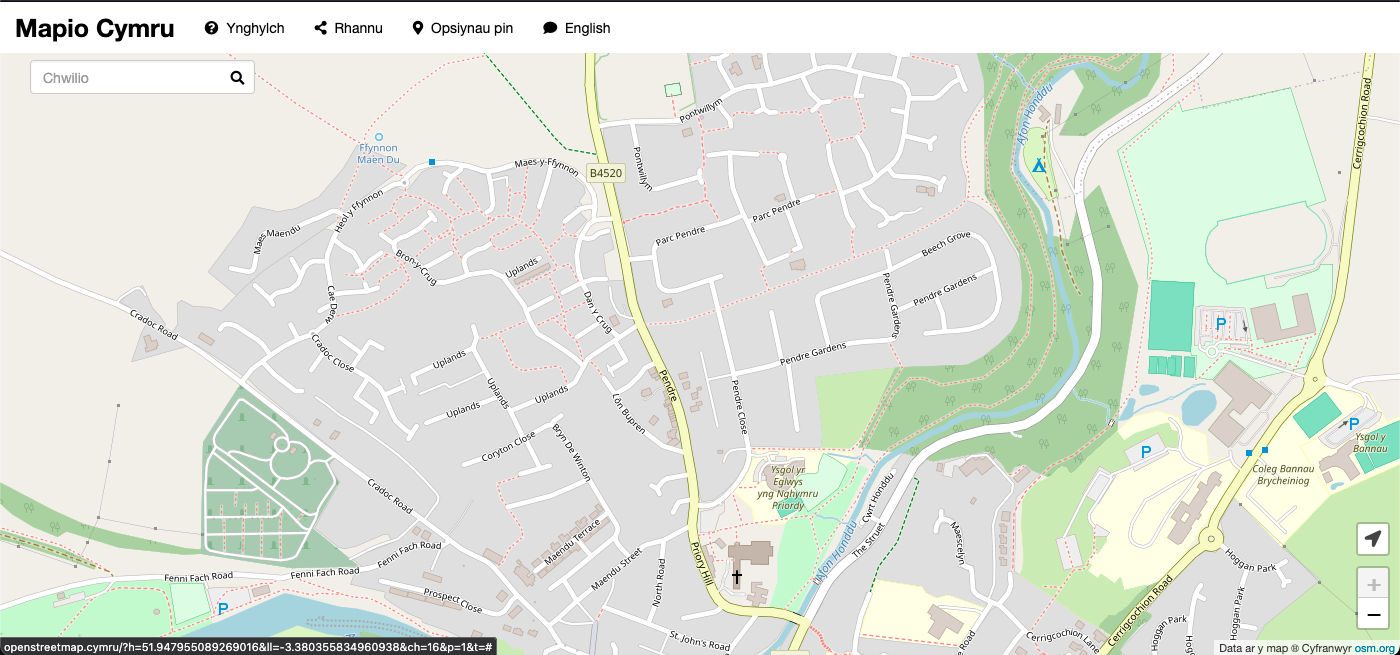
Mae Ben Proctor fy nghyd-aelod o dîm Mapio Cymru wedi darganfod adnodd gwerthfawr i unrhyw un sy’n cyfrannu at OpenStreetMap sef enwau strydoedd yr Arolwg Ordnans. Mae e wedi blogio am hyn:
Un o brif amcanion prosiect Mapio Cymru yw cynyddu’r nifer o enwau yn Gymraeg a gedwir ar OpenStreetMap fel data agored, adnodd hollbwysig er mwyn cefnogi apiau a gwasanaethau mapio a fydd ar gael yn Gymraeg yn y dyfodol.
Y ‘bwlch’ mwyaf yn nata data enwau yn OpenStreetMap yng Nghymru yw’r enwau ffyrdd y dylid eu defnyddio yn Gymraeg.
[…]
Drwy ddadansoddi’r data sydd ar gael mewn cynnyrch OS Open Roads daeth Ben i’r casgliad ei fod fel set data yn ddigon da i’w ddefnyddio:
[…]
Ar ôl dadansoddi’r gwahaniaethau amrywiol hyn, rydym wedi dod i’r casgliad bod set ddata Open Roads yr Arolwg Ordnans yn ffynhonnell ddigon da ar gyfer golygu pellach gan unigolion brwd. Buasai golygydd sy’n weddol gyfarwydd ag enwau ffyrdd yn Gymraeg yn gallu canfod llawer o’r problemau uchod a’u cywiro.
[…]
Darllenwch fwy: Gwella enwau ffyrdd ar fapiau Cymraeg yng Nghymru
Gwych iawn oedd cael cymryd rhan yn y digwyddiad Hacathon Hanes 2025 yn y Llyfrgell Genedlaethol, Aberystwyth ar 12 Chwefror eleni.
Roedd llu o setiau data ac adnoddau ar gael i’w hacio ac addasu ac yna creu prosiectau. Fe benderfynais cyfuno rhai o fy niddordebau mewn prosiect undydd – hanes ymgyrchu, heddwch, data, a mapio.
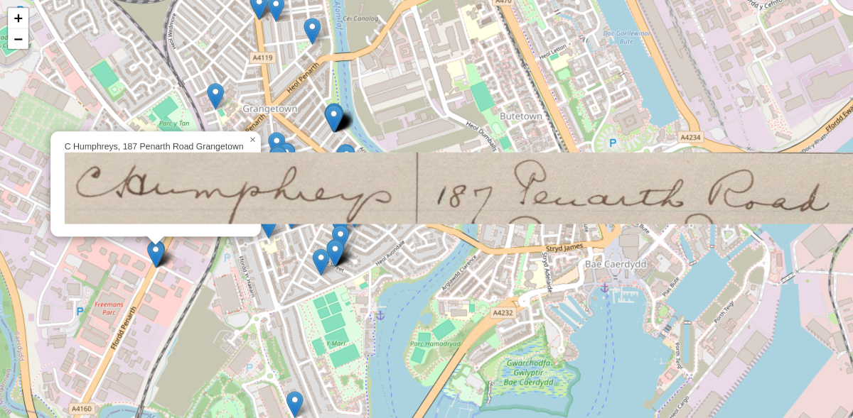
Yn y flwyddyn 1923 yn sgil erchyllderau’r Rhyfel Fawr roedd ymdrech fawr i drefnu deiseb heddwch. Yn y pen draw fe gasglwyd 390,296 o lofnodion gan fenywod yng Nghymru, oddeutu un trydydd o holl fenywod a merched Cymru ar y pryd. Chwarae teg iddynt! Aeth y ddeiseb ar dipyn o daith wedyn. Darllenwch yr hanes.
Dyma brototeip (cynnar iawn iawn) o fap cyfredol sy’n dangos llofnodion deiseb gan fenywod yn ardal Grangetown, Caerdydd.
Mae’r map yn ymdrech i:
Mae’r data lleoliad a delweddau yn dod o brosiect digido Deiseb Heddwch Menywod Cymru gan y llyfrgell ei hun a’i chriw o wirfoddolwyr.

Dw i eisoes yn gweld fy strydoedd lleol yma mewn ffordd wahanol.
Y prif heriau technegol i mi oedd cysoni a thacluso’r data, a chanfod lleoliadau’r map. O ran y data roedd pob cyfeiriad mewn maes unigol ac roedd ychydig o anghysondeb (a oedd yn adlewyrchu’r amrywiaeth yn y dogfennau gwreiddiol i fod yn deg). Roedd angen i mi wneud bach o gysoni gyda sgript a bach â llaw. Defnyddiais y set data agored OS Open Names i gael cyfesurynnau am ganol bob stryd (yn hytrach na rhywbeth fel API Google Maps sydd â chyfyngiadau ar ddefnydd dw i’n credu). Mae’r set data OS yn cynnig lleoliad canol y stryd a ‘bocs’ o amgylch y stryd.
Wrth gwrs mae angen llawer iawn mwy o lofnodion ar fy map. Mae cyfanswm o 69 ohonynt ar y fersiwn cyfredol. Bydd hi’n dda cael ymestyn i’r holl ddinas a’r holl wlad wedyn. Nid oes mynediad gyda fi at y data gwreiddiol rhagor.
Mae eisiau i mi ffeindio ffordd well o ddangos clwstwr o lofnodion sydd wedi dod o’r un stryd hefyd, o bosibl drwy ddefnyddio’r bocs o amgylch bob stryd. Roedd ychydig o orgyffwrdd yn y lleoliadau fesul stryd felly o’n i wedi cyflwyno bach o amrywiaeth randym – datrysiad cyflym dros dro oedd hyn!
Gobeithio bod modd diweddaru’r prosiect yn y dyfodol agos. Hoffwn i rannu’r cod tu ôl iddo hefyd.
Diolch i’r Llyfrgell am y croeso. Dyma erthygl gan Jason Evans sy’n cynnwys sôn am rai o’r prosiectau eraill.

Mae’r nodiadau isod yn perthnasol i newyddion dibynadwy, trafodaethau, gwrando ar arbenigwyr, dysgu, datblygu dealltwriaeth, a dwyn awdurdodau i gyfrif. Mae hyn i gyd yn bethau sydd yn bosibl i’w gwneud drwy ddefnydd o’r we, ar ei gorau.
Ar hyn o bryd mae hi’n teimlo i mi fod nifer o bobl yn ‘coroni’ gwahanol blatfformau penodol megis Bluesky fel Y Lle i gynnal sgyrsiau ar y we am bob pwnc dan haul, ac mae hynny’n codi llawer o gwestiynau i mi.
Ym mha ffordd a fyddai’r platfform o’ch dewis yn well na Twitter/X nawr ac yn dyfodol?
Beth yw’r risg?
Pa wersi ydyn ni’n dysgu o brofiad[au] Twitter/X? Beth am Myspace? A Facebook, ac ati?
Ydyn ni’n fodlon treulio llawer o amser i ymgartrefu ar blatfform am ychydig blynyddoedd, i ddechrau eto ar blatfform arall pan fydd y chwarae’n troi’n chwerw? (Dw i ddim eisiau gwneud hyn.)
Beth am y Gymraeg?
Yn ystod yr etholiad yn yr UDA roedd nifer o bobl a sefydliadau yn datgan bod nhw am adael Twitter/X. Un enghraifft oedd ysgol a gyhoeddodd “nad yw X yn alinio gydag ein gwerthoedd”… a bwriad yr ysgol i ymuno ag Instagram yn lle. Mae hyn eto yn codi cwestiynau.
Efallai bod Instagram yn teimlo fel lle neisach i dreulio amser yn 2024, ond mae hynny’n dibynnu yn llwyr ar bwy wyt ti.
Am wn i does dim llawer iawn o wahaniaeth pwysig rhwng Twitter/X ac Instagram: y pwrpas, y model masnachol, y model llywodraethiant, pwy sy’n rheoli, beth all digwydd ar ei waethaf (Meta yw perchennog Instagram a Facebook), felly ie, gwerthoedd eithaf tebyg hefyd.
Dw i’n llwyr ymwybodol o bwy yw Elon Musk ac dw i wedi bod yn dilyn yr hanes.
Rhaid nodi bod hefyd rhai ystyriaethau a phroblemau strwythurol gyda’r “we gorfforaethol” sy’n trosgynnu unigolyn.
Yn wir mae Bluesky mewn meddiant corfforiaeth buddiant cyhoeddus (PBC yn yr UDA). Mae hynny’n swnio’n addawol. A dweud y gwir does dim llawer iawn o ddealltwriaeth gyda fi eto o arwyddocâd hynny o ran llywodraethiant, risg a/neu “gost” hir dymor i ddefnyddwyr (dw i ddim yn cyfeirio at bris ariannol yn unig).
Ar hyn o bryd mae Tŵt Cymru yn cynnig cyfuniad apelgar i mi o ryngwyneb Cymraeg, rhyddid i symud i blatfform arall â fy holl ddilynwyr, y gallu i ddilyn defnyddwyr Saesneg gan gynnwys rhai ar weinyddwyr eraill, ac wrth gwrs dilyn nifer sylweddol – os nad anferth ar hyn o bryd – o ddefnyddwyr Cymraeg heb algorithm i’w boddi, polisïau sy’n edrych yn gall i mi, a llywodraethiant iachus hyd y gwelaf i.
Hynny yw dw i wedi cwrdd â’r person sy’n rhedeg Tŵt Cymru ac wedi cael peint yn y Blue Bell yng Nghaerdydd, ac mae modd gohebu’n uniongyrchol gyda fe gyda chwestiynau, problemau, syniadau, ayyb. Mae tîm cymedroli sydd hefyd yn ddefnyddwyr.
Mae’r blog hwn yn le da i mi rannu meddyliau hefyd (ac i’r rhai sydd â diddordeb mae modd cael ffrwd ActivityPub a/neu RSS). Mae’r blog yn rhedeg yn annibynol o unrhyw gwmni neu gorff heblaw am y perthnasau gyda chofrestrydd enw parth a chwmni lletya.
Gyda llaw… mae blogio’n lot haws pan dw i’n cynnwys ‘meddyliau’ neu ‘nodiadau’ yn y teitl yn hytrach na cheisio ysgrifennu darn feddylgar, craff, campus. 😂
Byddai hi’n braf tasai hi’n bosibl i ddilyn defnyddwyr Bluesky drwy weinydd Mastodon fel Tŵt Cymru, a’r ffordd arall, ac ymateb ayyb. Byddai hynny’n dibynnu ar ryw fath o ffederaleiddio yn y dyfodol. Efallai bod hynny yn gwbl amhosibl ac yn ddatganiad hollol nonsens, bydd rhaid i mi ymchwilio.
I’w barhau.
Yn y cyfamser diolch i Richard, Nwdls, ac eraill am ysgogi’r sgwrs.
Nod prosiect Mapio Cymru yw i wella’r genhedlaeth nesaf o wasanaethau mapio Cymru, ac ar fy rhan i mae ymhlith y prosiectau gwaith gorau erioed am ddysgu pethau newydd – am ddata agored, systemau gwybodaeth daearyddol, a sgiliau datblygu.
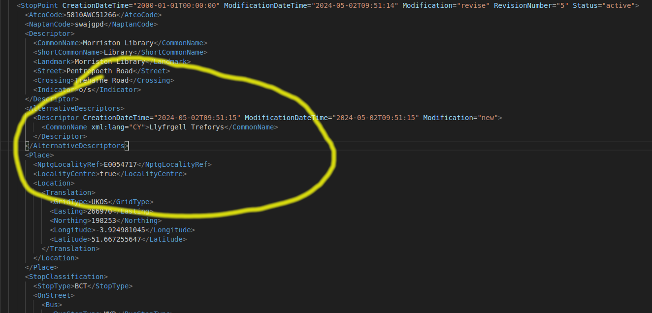
Ar flog y prosiect ysgrifennais eitem am newidiadau i NaPTAN sy’n rhestr fawr o bwyntiau trafnidiaeth gan gynnwys safleoedd bws a gorsafoedd trên.
Gwefan wici o adnoddau ar gyfer tyfu’r we agored Gymraeg yw Hedyn.
hedyn.net yw’i gyfeiriad.
Dw i newydd ddiweddaru’r feddalwedd tu ôl iddi hi (Debian a MediaWiki). Gadewch wybod os ydych chi’n gweld unrhyw broblemau pls!
Mae modd i chi, unrhyw un, gael cyfrif a chyfrannu adnoddau at Hedyn. Roedd rhaid diffodd y ffurflen creu cyfrif yn anffodus, oherwydd sbam.
Mae nifer o bethau wedi newid ers sefydlu’r wici yn 2009, e.e.
A dweud y gwir mae eisiau meddwl am ddefnydd Hedyn yn 2024 a thu hwnt. Pa rôl sydd i dechnolegau agored a meddalwedd rydd i ffyniant y Gymraeg? Beth sydd eisiau er mwyn cynnal sffêr gyhoeddus a democratiaeth iachus yng Nghymru a thu hwnt? Pa wersi ydyn ni’n gallu dysgu o hanes Twitter? Ydy’r delfryd o we agored Gymraeg yn freuddwyd gwrach? Beth am yr holl sgwrs am ymgacheiddio Tech Mawr? Mae digon yma i mi gnoi cil drosto.
Yn y cyfamser diolch i holl gyfranwyr Hedyn dros y blynyddoedd ac i Rhys Wynne yn benodol am ei holl help, cefnogaeth, a syniadau.
Dw i wedi ychwanegu ffrwd ActivityPub i fy mlog bellach, fel gwasanaeth arbrofol.
Dyma rai nodiadau am y profiad:
Ymwadiad:
Rhai nodiadau am WordPress yn benodol:
Mae’r blog yma bellach yn darparu ffrwd ActivityPub o’i holl eitemau.
Os ydych chi ar Mastodon (neu systemau eraill megis Pleroma, Friendica, HubZilla, Pixelfed, SocialHome, a Misskey yn ôl y sôn) fe gewch chi ddilyn y ffrwd trwy’r cyfeiriad @carl
Yn bennaf dyma brawf i weld beth sy’n ymddangos. Gadewch wybod am eich profiad trwy bostio ymateb Mastodon (neu system arall). Mae sylwadau ‘traddodiadol’ ar agor islaw hefyd.
Bydd rhaid i mi flogio mwy o nodiadau am y profiad.
DIWEDDARIAD (20 munud ar ôl cyhoeddi): dw i wedi ehangu’r rhestr o blatfformau. Mae chwech eitem yn lle dau bellach. Tybed os fydd hyn yn ymddangos yn y ffrwd ActivityPub.